Wallpolla Island project site
Wallpolla Island is a large and ecologically significant Murray River floodplain, supporting nationally important wetlands, forests and wildlife.
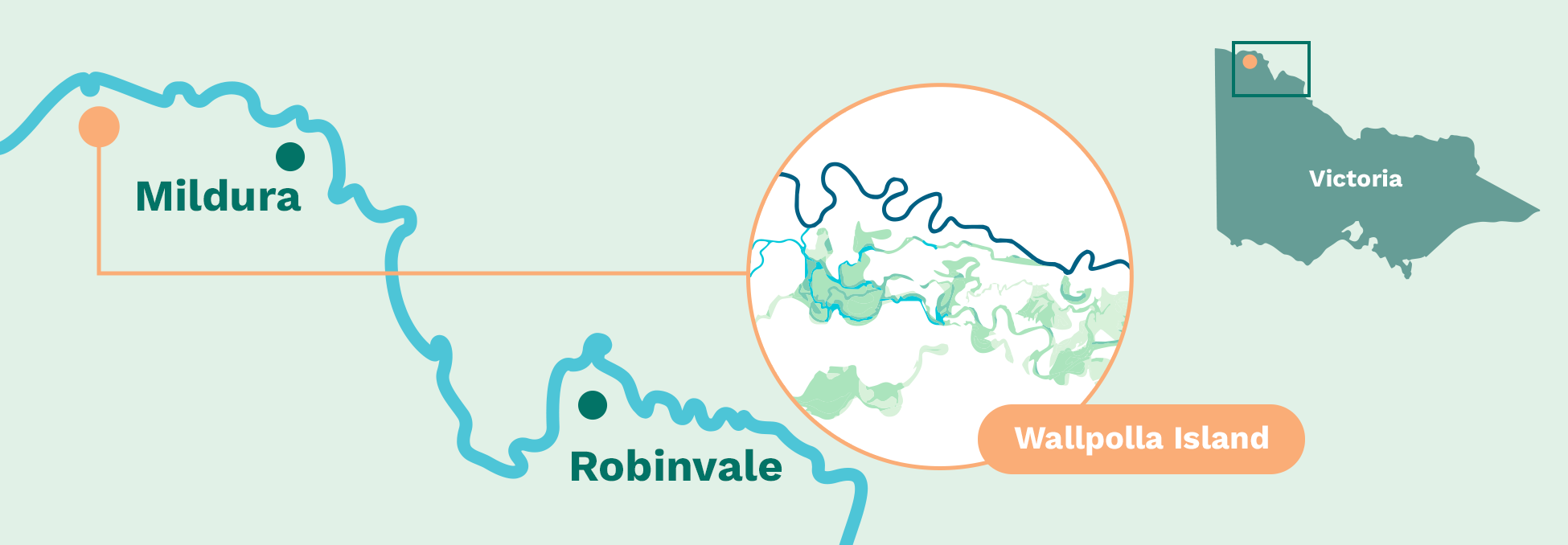
Location
North-west Victoria, approximately 30 km west of Mildura, immediately downstream of the junction of the Murray and Darling rivers.
Part of the Chowilla–Lindsay–Wallpolla floodplain within Murray-Sunset National Park and the Living Murray Chowilla Floodplain icon site.
 View on Google Maps
Information
Wallpolla Island forms part of a large, relatively flat floodplain shaped by the Murray River, with a network of permanent and temporary wetlands and flood-dependent vegetation. Wallpolla Creek plays a central role in moving water across the floodplain, linking the river to a mosaic of wetlands and low-lying habitats.
The floodplain supports river red gum forests, black box woodland, lignum shrubland and saltbush communities, which provide habitat for a wide range of native wildlife. These include frogs, waterbirds, small native fish and threatened species such as the growling grass frog, Giles' planigale and Murray cod.
Historically, Wallpolla Island flooded regularly, with water spreading across the floodplain often enough to sustain healthy vegetation and productive food webs. River regulation, including dams, weirs and levees, has reduced the frequency, duration and extent of natural flooding. In some parts of the floodplain, the time between floods has increased well beyond what flood-dependent plants and animals can tolerate.
The Wallpolla Island Floodplain Restoration Project will improve the way environmental water can be delivered to, moved across and retained on the floodplain. By working with natural river flows and using targeted infrastructure, the project aims to restore more natural flooding patterns and support healthier floodplain ecosystems.
Wallpolla Island is a place of deep cultural, spiritual and historical significance for Traditional Owners, including the First People of the Millewa-Mallee Aboriginal Corporation. Protecting cultural heritage and working closely with Traditional Owners is central to how the project is planned and delivered.
The project is currently progressing through planning and environmental assessment.
Project phase: Planning and environmental assessment
Fast facts
Living Murray icon site
Part of the Living Murray Chowilla Floodplain icon site.
Up to 2,672 hectares
Of floodplain targeted for restoration.
Diverse ecosystems
Supports red gum forest, black box woodland, lignum shrubland and wetlands.
Efficient water use
Improves environmental outcomes using less water than natural floods.
Targeted infrastructure
Uses gated structures (regulators), containment banks and temporary pumps to complement river flows.
Community values
Protects cultural, environmental, recreational and community values.
Project milestones
Coming soon.
Why floodplain restoration is needed
Floodplains depend on regular wet and dry cycles to remain healthy. These cycles support vegetation growth, trigger breeding events for fish and frogs, create feeding habitat for waterbirds and return nutrients to the river system.
Without intervention, the condition of wetlands, forests and habitats is expected to continue declining, reducing resilience to climate change and future dry conditions.
By restoring more natural flooding patterns, the project will help improve floodplain health, strengthen ecological resilience and support cultural, environmental and recreational values into the future.
Learn more: Wallpolla Island flooding frequency fact sheet (PDF)
What is being planned?
The project proposes new and upgraded floodplain infrastructure that will work alongside natural river flows and environmental water to improve inundation across Wallpolla Island.
Planned elements include:
- Large and small gated structures (regulators) to control water movement into creeks and wetlands
- Containment banks to help retain water on the floodplain
- Culverts to distribute water across different parts of the floodplain
- Temporary pump hardstands to deliver environmental water during extended dry periods
- Upgrades to existing access tracks where required
Infrastructure will be similar in scale to works delivered under The Living Murray program.
The infrastructure will allow water to be delivered under different conditions:
- During large natural floods, structures can be operated to allow water to flow through the floodplain
- When floods are shorter than needed, water can be held on the floodplain for longer
- During extended dry periods, environmental water can be used to 'top up' the floodplain to support ecological health
Where possible, infrastructure will be located on previously disturbed areas to minimise impacts on undisturbed landscapes and cultural heritage.
News and media
Coming soon.
Frequently asked questions
Why is Wallpolla Island being restored?
Flooding now occurs less often and for shorter periods across parts of the floodplain. Restoration will help return more natural flooding patterns, improving wetland health, forest condition and habitat for native species.
At Wallpolla Island, river regulation has reduced natural flooding and increased the length of time between floods. In some areas, dry periods are now far longer than the floodplain can tolerate, placing stress on vegetation and wildlife and reducing the floodplain's ability to recover after drought.
The area is an important cultural landscape. Thousands of years of Aboriginal history are reflected in culturally significant places across the floodplain. Floodplain restoration helps stabilise soils and reduce erosion, supporting the protection of these values.
2
Without action, vegetation condition and habitat quality are expected to continue declining, increasing risks to biodiversity, cultural heritage and the long-term resilience of the floodplain.
How will water be delivered?
Water will be delivered using a combination of:
- Natural high river flows
- Managed flows using gated structures (regulators)
- Temporary pumping during dry conditions
Different watering approaches will be used depending on river levels and floodplain condition. In some years, water may flow naturally onto the floodplain. In others, infrastructure will allow water to be held for longer or delivered to areas that would otherwise remain dry.
This flexible approach allows the project to respond to changing conditions while using water efficiently.
Will access to Wallpolla Island change?
During planning, there are no changes to access. During construction or watering events, some tracks may be temporarily affected, particularly during larger floods. Any changes will be communicated in advance where possible.
How is cultural heritage being managed?
Cultural heritage is a key consideration. A Cultural Heritage Management Plan is being prepared in consultation with Traditional Owners to identify, protect and manage cultural values before, during and after works.
Traditional Owners have cultural, spiritual and economic connections to land, water and resources through their relationship with Country, built over tens of thousands of years. Working closely with Traditional Owners is central to protecting cultural values and informing how the project is planned and delivered.
How does Wallpolla Island fit with other VMFRP sites?
Wallpolla Island is one of the floodplain sites being restored under the VMFRP. Together, these sites aim to improve the health of the Murray River floodplain at a landscape scale by restoring connectivity and strengthening ecological resilience.
Each site responds to local conditions and community context. At Wallpolla Island, this includes managing water across a large, low-lying floodplain with extensive creeks, wetlands and lignum shrublands that are highly sensitive to long dry periods.
By delivering coordinated benefits across multiple floodplains, the program helps support healthier rivers, wetlands and communities along the Murray.
How will success be measured?
Monitoring programs will track vegetation condition, water quality and wildlife response over time to understand how the floodplain is responding and whether ecological objectives are being met.
Who is delivering the project?
The VMFRP is delivered under the Murray–Darling Basin Plan by Lower Murray Water, in partnership with Goulburn-Murray Water, Mallee and North Central Catchment Management Authorities, Parks Victoria and the Department of Environment, Land, Water and Planning, through funding from the Australian Government's Department of Climate Change, Energy, the Environment and Water.
Learn more:
Sign up to receive updates
If you would like to receive email updates relating to the Wallpolla Island project site, please register here:
Contact the project team
If you have questions about the Wallpolla Island project site, or would like to provide feedback, please email the project team: info@vmfrp.vic.gov.au and we'll put you in touch with the right person.