News
12 September 2022
Tangled Lignum – the unsung zombie hero of the floodplains
Tangled Lignum (Photo: Professor Fiona Dyer, University of Canberra)
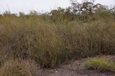
Tangled Lignum (Duma florulenta) is a much-underrated shrub that grows up to 2.5 m tall and forms extensive shrublands across intermittently flooded swamps, river flats and ephemeral lakes. Lignum is found at most VMFRP sites with Burra Creek being a particularly good spot to see healthy Lignum. In dry periods, Lignum may appear lifeless, but like a floodplain feature special of ‘Return of the lignum dead’, it springs back to life after flooding from high river flows, providing homes and food for a diverse range of plants and animals found nowhere else (Freestone et al.).
During wet times and dry, Lignum plays a key ecological role in the floodplain ecosystem. Flooded Lignum provides a nesting platform for water birds keeping them close to food and away from predators. Meanwhile under the water, its tangled branches provide food and shelter for frogs and young fish during their vulnerable growing stage (Jensen et al.).
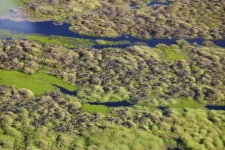
Colonial waterbirds, including Ibis nesting on Lignum, at flooded wetlands (Photos: Professor Fiona Dyer, University of Canberra)
When dry, Lignum shrublands provide foraging and hiding places for small mammals. It’s the preferred habitat of the Giles’ planigale, a threatened species under the Victorian Flora and Fauna Guarantee Act 1988, found at Lindsay and Wallpolla Islands.
Once flooded, Lignum usually grows and flowers rapidly, but if it goes too long without flooding, it becomes unhealthy and less responsive, taking longer to bounce back (Freestone et al). This in turn makes the many animal and plant species that call Lignum home, like the planigale, more vulnerable to the impacts of climate change.
Lignum in decline
Just like River Red Gum and Black Box, Lignum is in decline on Murray River floodplains. In the short space of 70-odd years, river regulation has reduced the amount of water reaching Lignum, making the floodplain wait too long in between drinks. Ecologists have shown that the reduction of water reaching the Murray River floodplain has resulted in a ‘severe’ level of ecological change, impacting on the capacity of the floodplain – including Lignum shrublands – to provide food, homes and ecosystem services upon which we all depend. Unless we intervene by returning more water more often to the Murray River floodplain, many hundreds of flood-dependent plants and animals will be unable to complete their lifecycles under hotter and drier conditions from global warming and are likely to disappear.
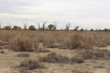
Severely degraded lignum shrubland at Lindsay Island (Photo: David Wood, Program Manager The Living Murray, Mallee CMA)
Common and widespread species like Lignum play a huge role in maintaining health and resilience of floodplains. Because of their relative abundance and ability to occupy space, common species do a lot of heavy ecological lifting including habitat supply, food from photosynthesis and filtering nutrients thereby maintaining clean waterways and soil. Because of their predominance, common species are supreme networkers, establishing direct and indirect ‘contacts’ responsible for sustaining a myriad of plant and animal species. For this reason, plants like Lignum are known as keystone or foundation species. They hold together and support the complex web of relationships that make floodplains diverse and vibrant sources of life.
Taking steps to restore widespread common species like Lignum has tremendous flow-on benefits for floodplains and the many species that call floodplains home.
New approaches to tracking the health of Lignum
To date, it’s been quite hard to track the health of Lignum relying on subjective visual measures from a limited number of locations. This problem has greatly limited our ability to manage Lignum effectively. But new technology is helping to address this problem. Researchers at Canberra University are developing an exciting new approach using images taken by drones, ground data collected by ecologists and a type of artificial intelligence called ‘machine learning’. To date, they have had great success mapping the health of reed beds of the Great Cumbung Swamp in south-western New South Wales (Higginson et al) and are planning to adapt the method to Lignum shrublands. This will give us a more complete and accurate perspective on the secret life of Lignum.
Mallee Catchment Management Authority is watching these futuristic monitoring techniques to see what can be built into the monitoring and evaluation plans for the VMFRP sites. Watch this space!
Find out more
If you would like to see Lignum for yourself, Burra Creek is a great spot to see healthy lignum (between Piangil and Kenley about 25 km north of Nyah). Visit our interactive map on the EES portal to see the location of Burra Creek and other VMFRP sites.
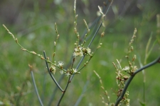
Flowering Lignum (Photo: Professor Fiona Dyer, University of Canberra)
References
Freestone F.L, Brown P, Campbell C.J, Wood D.B, Nielsen D.L, Henderson M.W., (2017) Return of the lignum dead: Resilience of an arid floodplain shrub to drought, Journal of Arid Environments, Volume 138, pp. 9-17, https://doi.org/10.1016/j.jaridenv.2016.11.011.
Higgisson W, Cobb A, Tschierschke A, Dyer F (2021). Estimating the cover of Phragmites australis using unmanned aerial vehicles and neural networks in a semi-arid wetland. River Research and Applications, 37(9), 1312– 1322. https://doi.org/10.1002/rra.3832.
Jensen, A, Walker K.F, Paton, D. (2008). The secret life of tangled lignum, Muehlenbeckia florulenta (Polygonaceae): little-known plant of the floodplains, Wetlands of the Murrumbidgee River Catchment: Practical Management in an Altered Environment, pp.79–85.
Subscribe below for more news
We ask for your personal information so we can send you relevant updates. See our privacy statement.