Burra Creek project site
Burra Creek is a long side channel of the Murray River, supporting well-preserved floodplain woodlands, wetlands and culturally significant landscapes.
Project status: Following the Victorian Minister for Planning's assessment of the Environment Report, the Burra Creek Floodplain Restoration Project will not proceed. This page provides background information and access to environmental assessment materials.
Location
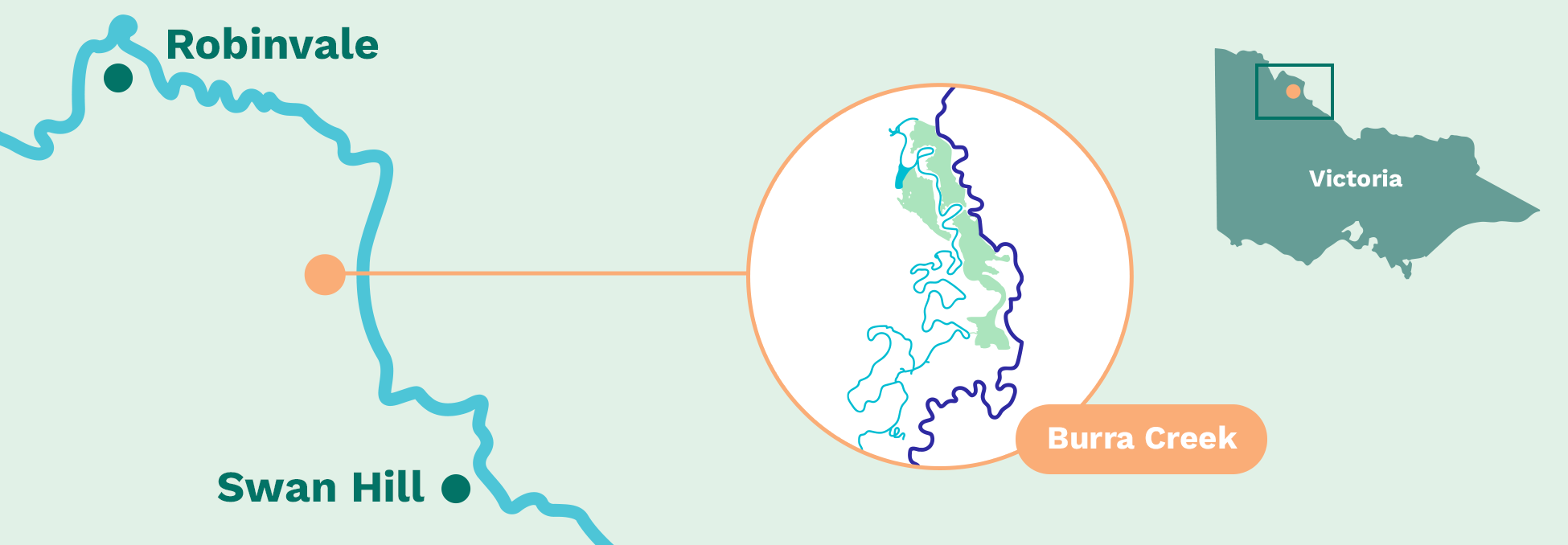
North-west Victoria, approximately 50 km north-west of Swan Hill, between the rural localities of Piangil and Kenley.
Located along a 54 km side channel (anabranch) of the Murray River on the western side of the river corridor.
 View on Google Maps
Information
Burra Creek was identified as a high-value floodplain system considered for restoration under the VMFRP due to its ecological condition, landscape connectivity and cultural significance. The site includes a long, meandering side channel (anabranch) of the Murray River, flanked by river red gum forests, black box woodland, lignum shrubland and wetlands.
Historically, Burra Creek received regular flows from the Murray River, with winter and spring flooding supporting flood-dependent vegetation and productive food webs. River regulation, access tracks and artificial blockages have reduced the frequency, duration and extent of these floods, leading to longer dry periods across parts of the floodplain.
As a result, some floodplain vegetation communities — particularly lignum shrubland and higher elevation black box and red gum woodlands — now experience extended periods without flooding. This places stress on trees, reduces understorey condition and limits habitat availability for native wildlife.
Burra Creek supports a diverse range of species, including frogs, waterbirds, reptiles and native fish, as well as threatened species such as the Regent Parrot, Broad-shelled Turtle, Murray Cod and Flathead Galaxias. The area is also a valued recreational landscape used for camping, fishing and nature-based activities.
The Burra Creek project proposed to improve floodplain connectivity by working with natural river flows and targeted infrastructure to restore more natural flooding patterns across approximately 403 hectares of floodplain and anabranch habitat. Proposed works were designed to improve ecological condition while using environmental water efficiently and avoiding impacts on surrounding agricultural land.
Burra Creek is also a place of deep cultural, spiritual and historical significance for First Nations people. Protecting cultural heritage and engaging closely with Traditional Owners was a central consideration throughout project planning and assessment.
Following completion of the environmental assessment process, the Victorian Minister for Planning determined that the project would not proceed. Materials developed during the assessment remain available to support transparency and future learning.
Project status: Not proceeding following Minister for Planning's assessment.
Fast facts
50 km north-west of Swan Hill
Located approximately 50 km north-west of Swan Hill.
403 hectares
Of floodplain and anabranch habitat assessed.
54 km anabranch
Of the Murray River.
Diverse ecosystems
Supports river red gum forest, black box woodland, lignum shrubland and wetlands.
25+ significant species
Habitat for more than 25 significant native species.
Assessment completed
Environmental assessment completed; project will not proceed under VMFRP.
Why floodplain restoration was investigated
Floodplains rely on regular wet and dry cycles to remain healthy. These cycles support vegetation growth, trigger breeding events for fish and frogs, create feeding habitat for waterbirds and return nutrients to the river system.
At Burra Creek, river regulation and artificial barriers have reduced natural flooding and increased the length of time between flood events. In some vegetation communities, the interval between floods is now far longer than what flood-dependent plants and animals can tolerate.
What was assessed?
The environmental assessment investigated potential ecological benefits and impacts associated with restoring more natural flooding at Burra Creek, including:
- Changes to flooding frequency, duration and extent
- Effects on floodplain vegetation, wetlands and threatened species
- Potential impacts on Aboriginal cultural heritage
- Water quality, groundwater and downstream effects
- Land use, access, recreation and community values
A range of design options and mitigation measures were examined as part of this process.
Frequently asked questions
How does Burra Creek fit with other VMFRP sites?
Burra Creek was one of nine floodplain sites considered under the VMFRP, which aims to improve the health of Murray River floodplains at a landscape scale.
While the Burra Creek project will not proceed, investigations at the site have contributed to a broader understanding of floodplain processes, ecological thresholds and community considerations that inform floodplain restoration planning across the Murray system.
How is information from the Burra Creek assessment used?
Although the project will not be delivered, information gathered through the Burra Creek environmental assessment continues to support transparency, inform future planning and support knowledge sharing across floodplain restoration programs.
Who is delivering the VMFRP?
The VMFRP is delivered under the Murray–Darling Basin Plan by Lower Murray Water, Goulburn-Murray Water, Mallee and North Central Catchment Management Authorities, Parks Victoria and the Department of Environment, Land, Water and Planning, through funding from the Australian Government's Department of Climate Change, Energy, the Environment and Water.
Learn more:
Contact the project team
If you have questions about the Burra Creek site or the environmental assessment materials, please email the project team: info@vmfrp.vic.gov.au and we'll put you in touch with the right person.