Nyah project site
The Murray River and its floodplains are central to the identity of regional communities like Nyah, as places of environmental, recreational, and cultural significance.
 View on Google Maps
Information
The Murray River and its floodplains are central to the identity of regional communities like Nyah, as places of environmental, recreational, and cultural significance.
Flooding across Nyah-Vinifera Park does not occur as frequently as it once did, so water spreads across the floodplain less often. Over time this has left some areas drier and reduced healthy habitat for plant and animal species.
We are currently preparing for construction works to create a system of containment banks and regulators that will allow water to move across the floodplain in a controlled and carefully timed way.
Currently, water can be delivered to parts of the Nyah floodplain, but only in limited volumes and for restricted periods of time. New works will help manage water movement to support ecological health.
Environmental watering will help regenerate native trees, grasses and understorey plants, stabilise sandy soils, and restore habitat for wildlife that depend on healthy landscapes to survive.
Nyah-Vinifera Park holds deep cultural and historical importance for Traditional Owners, and protecting cultural heritage is central to ensuring the park remains healthy, resilient and protected for future generations.
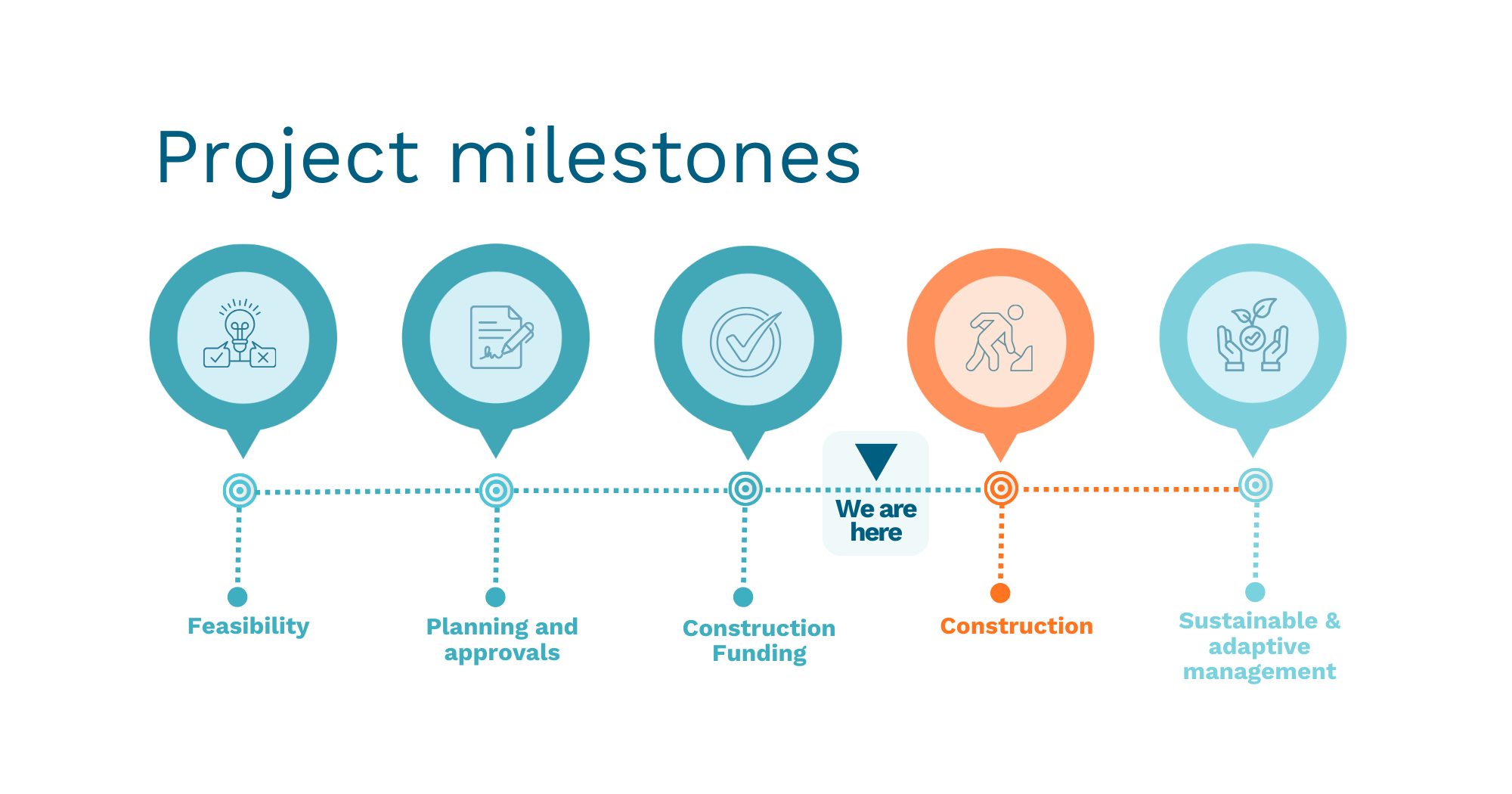
Project phase: Pre-construction
Fast facts
475 hectares
Of lakes and floodplain targeted for improved ecological health.
Threatened species
Eastern grey egret, grey-crowned babbler, regent parrot, carpet python, white-bellied sea eagle, broad shelled turtle.
Cultural significance
Aboriginal cultural significance acknowledged and respected.
Local employment
Opportunities during construction.
Reliable habitat
Breeding and feeding habitat for fish, frogs and water birds.
Healthy landscapes
Supporting healthy landscapes and community wellbeing.
Project milestones
Works update
Preliminary site investigations and assessments are currently taking place within the park.
What is happening at Nyah?
Sections of raised containment banks and gated structures known as regulators will be constructed as part of the managed water system being delivered at Nyah through the VMFRP. These structures will allow water to be released onto, held within and moved across the floodplain to support floodplain health, and cultural values.
Visitors are asked to take care when travelling through the park and to follow all signage and directions.
Maps
Coming soon.
News and media
Coming soon.
Frequently asked questions
Why are floodplain restoration works required at Nyah?
Over time, the Murray River has been regulated with weirs, dams and levees to support communities, agriculture and industry. While this has delivered many benefits, it has reduced the frequency, duration and extent of natural flooding required to keep landscapes healthy. Before river regulation, the red gum forests and wetlands on the Nyah floodplain flooded every 1-2 years. These flooding events are now much less common.
Restoring flooding in a carefully managed way will help support the health and resilience of these landscapes into the future. It will mean water can be released onto the floodplain, held by containment banks, and released back into the river at the optimum time.
What happens if the floodplains are not restored?
The Murray River and its floodplains are part of an interconnected ecosystem that depends on natural wet and dry cycles to stay healthy and keep the river rich with nutrients. Reduced flooding has increased stress on floodplain vegetation, weakened tree canopies and reduced habitat and food for wildlife. Without intervention, these iconic Australian landscapes will continue to decline, placing biodiversity, cultural values and regional communities at risk. If we do not intervene, these landscapes may decline beyond the point of rejuvenation.
What is happening at Nyah?
Five gated structures, known as regulators, and a series of containment banks will be constructed alongside existing tracks to hold water on the floodplain during flooding events. An elevated rocky drop structure will be installed to slow the water's return to the river.
Why was Nyah chosen?
Nyah-Vinifera Park is home to old red gum forests, billabongs and wetlands. The native vegetation and wildlife form an essential biodiversity corridor that connects the semi-arid Mallee landscape with the Murray River floodplain. The park is an important place of connection for Traditional Owners and the broader community, which must be preserved for future generations.
How is the Nyah-Vinifera Park being protected from construction impacts?
Protecting Nyah-Vinifera Park is a priority. Construction is guided by approved environmental and cultural heritage management plans, with guidelines in place to protect vegetation, wildlife, water quality and culturally significant areas. Works are carefully planned and monitored in collaboration with project delivery partners and Traditional Owners to minimise impacts during construction.
Where possible, construction will take place on existing access tracks and areas that have already been disturbed.
Plans have been developed through an extensive environmental assessment process that has satisfied both the Australian and Victorian Governments that the project will achieve its ecological, social and cultural objectives while minimising environmental impacts during construction and beyond.
Long-term monitoring of ecological, cultural and social outcomes will be undertaken before, during and after flood events to ensure the intended benefits are realised. Where outcomes do not align with expectations, management approaches will be adapted over time, including adjustments to future watering plans, to ensure the project's objectives are achieved.
Will trees be removed as part of the works?
To support the long-term health of the floodplain and enable works to be carried out safely and effectively, a limited number of trees will be removed within the defined construction footprint. Tree removal has been carefully assessed through the project's environmental approvals process, and the footprint has been refined to minimise impacts wherever possible.
Removed timber will be repurposed wherever feasible, including for fish and wildlife habitat, park improvements, and contribution to existing firewood programs, in compliance with all relevant approvals and environmental controls.
How will water be delivered to the Nyah floodplain?
Water will be delivered through a combination of natural inflows and managed temporary flows. Decisions are based on seasonal conditions, river flows and monitoring of floodplain health, with flooding planned in advance to support ecological outcomes while managing safety, access and water quality risks.
Will park access be restricted during flow events?
Parts of the Nyah-Vinifera Park will close to the public during planned flooding events to ensure safety. Watering events will mostly occur in winter and spring for two to four months. Larger flooding events will result in most of the park being temporarily closed.
Local communities will be notified in advance, and details will be posted on the Parks Victoria website.
How does Nyah fit in with the broader VMFRP project?
The infrastructure at Nyah is one part of a package of works being delivered in Victoria under the Murray Darling Basin Plan. Floodplain infrastructure is designed to target specific ecological outcomes at each site. The decision to release water at a particular site is based a series of factors determined by a holistic approach to keeping the Murray and its floodplains healthy. Planning and delivery of environmental water operations is coordinated via catchment management authorities, in consultation with stakeholders including Traditional Owners, land managers, water authorities and the local community, and informed by the results of ecological monitoring programs.
How does the VMFRP support environmental watering programs?
Planning and delivery of environmental water operations is coordinated through catchment management authorities in consultation with stakeholders including Traditional Owners, land managers, water authorities and the local community, and informed by the results of ecological monitoring programs. Coordinated infrastructure systems support better ecological outcomes at sites that are either difficult or impossible to reach under our current environmental watering program.
How do we know the project will work?
The VMFRP partners and specialist engineers and scientists have been working together on the Nyah design since 2012. The project has undergone a rigorous State and Australian Government environmental assessment process to understand potential impacts and benefits. Similar infrastructure delivered by other Victorian projects such as the Living Murray site at Hattah Lakes has shown that reconnecting rivers and floodplains improves ecological health, providing evidence that the works will deliver lasting benefits.
What has been the approvals pathway for this project?
The project has been progressed through a comprehensive planning and approvals pathway under relevant local, state and federal legislation. This process has included detailed technical investigations, environmental and cultural heritage assessments, and assessment of potential construction and operational impacts. Community and stakeholder engagement has been undertaken throughout planning and assessment to inform project design and ensure local knowledge and feedback were considered. The Environment Report (ER) represents the culmination of this work, bringing together extensive studies, consultation and independent review to demonstrate that the project meets approval requirements and can be delivered in accordance with statutory and regulatory obligations.
How are Traditional Owners involved?
Traditional Owners have cared for and sustainably managed the cultural landscapes of the Murray River and its floodplains for thousands of years. The VMFRP projects are considered culturally significant, and each contains a number of registered heritage sites. Traditional Owners have been involved with the VMFRP since 2014, and extensive work has been undertaken on Country to understand Traditional Owners land and water aspirations to guide watering of the floodplain.
The Aboriginal Heritage Act 2006 describes a legislative pathway for protection of Aboriginal cultural heritage in Victoria which includes detailed on-ground assessments to document cultural heritage sites and consultation with Traditional Owners on the proposed works and their potential impacts. The outcomes of assessments, along with proposed measures for protection, are documented in a Cultural Heritage Management Plan.
VMFRP partners have long-standing relationships and partnerships with First Nations People, and the project team is committed to working with First Nations People Traditional Owners to explore opportunities that support self-determination and healthy Country.
How is cultural heritage being managed?
Traditional Owners have cared for and sustainably managed the cultural landscapes of the Murray River and its floodplains for thousands of years. The VMFRP projects are located on land that holds significant Aboriginal cultural value and includes places of registered cultural heritage significance. A Cultural Heritage Management Plan has been prepared for the Nyah site in consultation with Traditional Owners and specialist consultants. The plan assesses the potential impact on Aboriginal cultural heritage and outlines protections before, during and after construction. These plans are required under the Aboriginal Heritage Act 2006 (Vic.)
Who is responsible for the project?
The VMFRP is funded by the Australian Government and delivered by the Victorian Government, Lower Murray Water, Mallee and North Central Catchment Management Authorities and Parks Victoria.
Sign up to receive updates
If you would like to receive email updates relating to the Nyah project site, please register here:
Contact the project team
If you have questions about the Nyah project site, or would like to provide feedback, please email the project team: info@vmfrp.vic.gov.au and we'll put you in touch with the right person.